Quick Answer: Drone construction monitoring uses scheduled aerial flights to track project progress, document site conditions, create 3D models, and generate stakeholder reports. Flights take 1-3 hours per visit, producing orthomosaics, progress comparisons, and volume calculations that replace hours of manual site documentation.
What Drone Construction Monitoring Covers
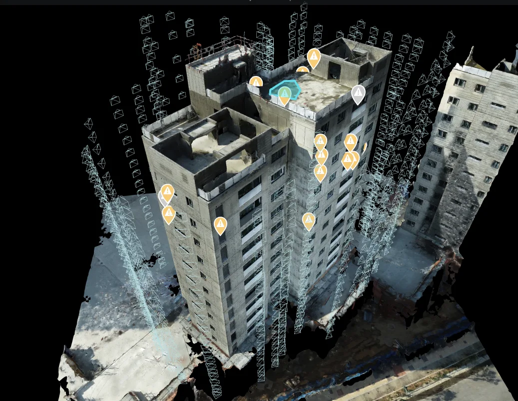
Construction site monitoring replaces manual progress photography and periodic site walks with systematic aerial documentation. An FAA-certified pilot flies a pre-programmed grid over the site at regular intervals, capturing overlapping images that are processed into actionable deliverables.
Key applications for project managers:
- Progress verification — Compare actual construction against the planned schedule using time-stamped imagery
- Quality documentation — Record concrete pours, structural steel placement, MEP rough-in, and envelope installation before they are covered
- Safety monitoring — Identify unsafe conditions (missing barriers, improper stockpiling, unauthorized access) from aerial perspective
- Stakeholder reporting — Generate visual progress reports for owners, lenders, and investors without requiring site visits
- Dispute resolution — Time-stamped documentation provides evidence for schedule claims, change orders, and quality disputes
Standard Deliverables
Each monitoring flight produces:
- Orthomosaic map — Scale-accurate aerial image of the entire site, suitable for measurement and overlay on site plans
- 3D site model — Photogrammetric 3D model showing terrain, structures, and equipment in their current positions
- Progress comparison — Side-by-side or overlay comparison with previous flights showing changes over time
- Volume calculations — Cut/fill volumes for earthwork, stockpile measurements for material tracking
- Time-lapse compilation — Assembled from sequential orthomosaics to show project evolution for stakeholder presentations
How Often to Fly
| Project Phase | Recommended Frequency | Rationale |
|---|---|---|
| Site preparation / earthwork | Weekly | Volume changes rapidly; tracks grading progress and material movement |
| Foundation / structural | Bi-weekly | Document critical structural milestones before they are covered |
| Vertical construction | Bi-weekly to monthly | Track floor-by-floor progress and facade installation |
| MEP / interior fit-out | Monthly | Exterior changes slow; interior work not visible from aerial |
| Final completion / punch list | As needed | Document completion conditions for closeout |
Software Integration
Drone monitoring data integrates with major construction project management platforms:
- DroneDeploy — Direct upload for interactive mapping, measurement, and team collaboration
- Procore — Attach orthomosaics and reports to project records
- Autodesk Construction Cloud — Overlay drone models on BIM coordination models
- Standard exports — GeoTIFF, OBJ, LAS point clouds compatible with any GIS or CAD platform
Monitoring by Project Type
| Project Type | Key Monitoring Focus | Recommended Frequency | Typical Program Cost |
|---|---|---|---|
| High-rise residential | Floor-by-floor progress, facade installation, crane placement | Bi-weekly | $15,000 - $30,000/year |
| Commercial office | Structural steel, curtain wall, MEP coordination | Bi-weekly | $12,000 - $25,000/year |
| Infrastructure (bridge, road) | Earthwork volumes, alignment verification, erosion control | Weekly | $20,000 - $40,000/year |
| Mixed-use development | Multi-phase coordination, site logistics, progress reporting | Weekly to bi-weekly | $15,000 - $35,000/year |
| Renovation/restoration | Before/after documentation, phased demolition, facade work | Monthly | $8,000 - $15,000/year |
ROI Breakdown: Real Dollar Examples
For a $50 million commercial construction project with a 12-month monitoring program costing $25,000:
- One avoided schedule dispute — Contractors filing delay claims without drone evidence typically cost $100,000-$500,000 to resolve. With time-stamped drone imagery proving actual site conditions, one defended schedule dispute pays for 4-20 years of monitoring.
- Reduced change order disputes — Visual documentation of site conditions at the time of change directives reduces disputed change order costs by an estimated 15-25%. On a $50M project with $2M in change orders, that is $300,000-$500,000 in reduced disputes.
- Earlier defect detection — Catching a waterproofing installation error during construction costs $5,000-$10,000 to fix. Discovering it 2 years post-completion after water intrusion has caused damage costs $100,000+. Drone monitoring catches these issues in real time.
- Safer job site — Each avoided lost-time safety incident saves $30,000-$80,000 in direct costs (medical, insurance, investigation) plus schedule delays.
The total program cost of $25,000 represents 0.05% of project value. A single avoided dispute or defect typically returns 4-20x that investment.
Getting Started
Starting a construction drone monitoring program is straightforward:
- Pre-construction baseline — Capture existing site conditions before breaking ground (protects against pre-existing condition claims)
- Define flight schedule — Align monitoring frequency with your project schedule milestones
- Set deliverable requirements — Choose between standard packages (orthomosaic + progress photos) and comprehensive packages (3D model + volume calculations + BIM overlay)
- Integrate with your PM tools — Connect drone data to Procore, ACC, or your preferred platform
For Florida construction projects, contact our team to discuss a monitoring program tailored to your project schedule and deliverable requirements.
Need a Building Inspection?
Get a free consultation and custom quote — 1-hour average response time. PE-certified reports. significantly less than scaffolding.
Frequently Asked Questions
How often should drone monitoring flights occur?
Most construction projects benefit from weekly or bi-weekly flights during active phases. Monthly flights work for slower-moving projects. High-stakes milestones (foundation pour, topping out, facade completion) may warrant additional flights.
What deliverables does drone monitoring produce?
Standard deliverables include orthomosaics (scale-accurate aerial maps), 3D site models, progress comparison overlays (current vs planned vs previous), volume calculations for earthwork, and time-lapse sequences for stakeholder presentations.
Can drone data integrate with project management software?
Yes. Drone data exports in standard formats compatible with Procore, Autodesk Construction Cloud, DroneDeploy, and similar platforms. Orthomosaics overlay directly on site plans for visual progress tracking.
What is the cost of ongoing construction monitoring?
Regular monitoring programs typically run $500-$2,000 per flight depending on site size and deliverables. Monthly contracts offer volume pricing. The cost is typically a fraction of 1% of project value.