Quick Answer: Drone inspection accelerates insurance claim documentation by providing comprehensive, date-stamped, GPS-referenced damage evidence within 24-72 hours of a loss event. The thoroughness and objectivity of drone data — combined with PE certification — produces stronger claims and faster settlements.
Why Drone Documentation Matters for Claims
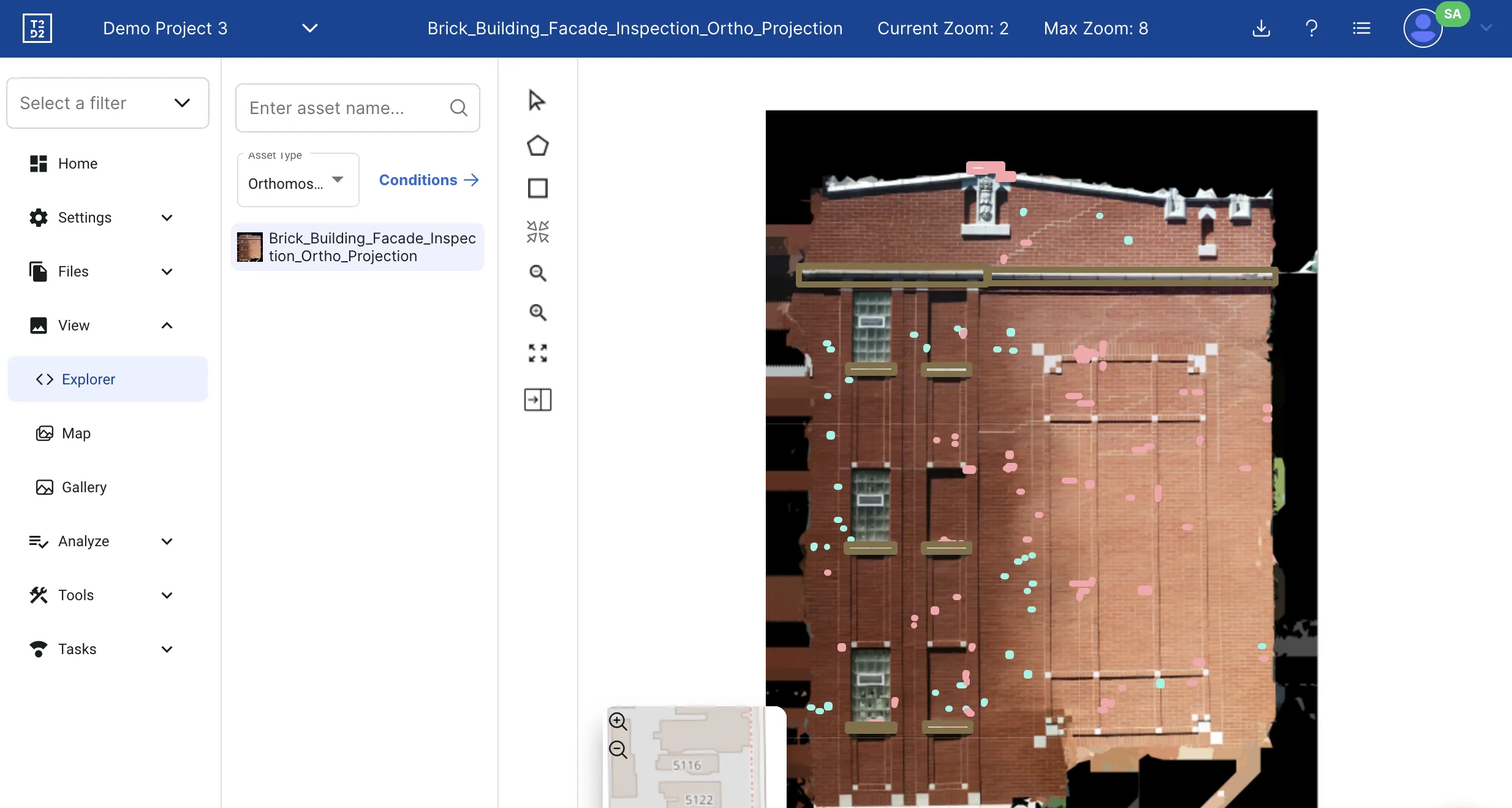
Insurance claims hinge on evidence. The more comprehensive, objective, and well-documented the evidence, the smoother the claims process. Drone inspection provides a level of documentation that manual methods cannot match:
- 100% coverage — Every surface of the roof and facade documented, not just accessible areas
- GPS coordinates — Every image tagged with exact location data, creating an undeniable record of where damage exists
- Date and time stamps — Flight metadata proves when documentation was captured
- Measurable data — Damage areas calculated in square feet from calibrated imagery
- Repeatable — The same flight path can be flown again for comparison
This objectivity is particularly valuable in Florida, where hurricane season produces a surge of claims and adjusters must process high volumes quickly.
Types of Insurance Claims Drones Support
| Claim Type | What Drones Document | Key Advantage |
|---|---|---|
| Hurricane / wind damage | Roof membrane tears, missing shingles, flashing displacement, facade debris impact | Full roof coverage before tarps are applied |
| Hail damage | Impact dents, granule loss, membrane punctures across entire roof | Pattern documentation proves widespread damage vs isolated spots |
| Flood / water intrusion | Water lines on exterior, foundation exposure, drainage failure | Thermal imaging reveals moisture extent inside walls |
| Fire damage | Structural charring, heat damage zones, roof collapse areas | Safe documentation without entering compromised structure |
| Building collapse / structural | Failure zones, debris patterns, remaining structure condition | 3D models support forensic engineering analysis |
The Claim Documentation Process
- Contact your insurer — Report the claim and document temporary measures taken to prevent further damage
- Schedule drone inspection — Drone roof and facade inspection should be performed before temporary repairs alter the damage evidence
- AI damage analysis — AI classification inventories every defect with type, severity, GPS location, and affected area
- PE assessment — Licensed engineer reviews findings and provides professional opinion on damage scope, cause, and recommended repairs
- Submit documentation — Deliver the complete package to your adjuster: orthomosaic map, annotated images, defect inventory, PE report
Pre-Loss Documentation
The strongest insurance position includes baseline documentation captured before a loss event. A pre-loss drone inspection establishes:
- The condition of the roof and facade before the storm
- Any pre-existing conditions that were not caused by the loss event
- A direct comparison point for post-loss damage assessment
Building owners who maintain annual or bi-annual inspection programs automatically build this documentation library. When a claim arises, they can demonstrate precisely what damage is new versus pre-existing.
Post-Storm Response
After a major storm, timing matters. Document damage as quickly as possible:
- 24-48 hours — Ideal window for post-storm documentation before temporary repairs begin
- 72 hours — Most drone inspection teams can deploy within this window after major events
- Airspace note — FAA may impose Temporary Flight Restrictions (TFRs) after major hurricanes. Licensed operators monitor TFRs and deploy as soon as airspace reopens
In Florida's hurricane season (June-November), having a drone inspection provider on standby before storm season reduces response time when it matters most.
What Insurers Want to See
Claims adjusters evaluate documentation based on:
- Comprehensive coverage — Was the entire roof/facade documented, or just selected areas?
- Image quality — Are defects clearly visible and identifiable in the imagery?
- Professional assessment — Is there an engineer's opinion on damage scope and causation?
- Damage quantification — Are affected areas measured (square footage), not just photographed?
- Causation clarity — Can the damage be attributed to the specific loss event versus pre-existing conditions?
Drone inspection with AI analysis and PE certification addresses every one of these criteria. The result is faster claim processing, fewer disputes, and more accurate settlements.
Insurance Claim Documentation Checklist
Before filing your claim, ensure you have:
- Date-stamped aerial imagery — High-resolution photos of all damaged areas with GPS coordinates and flight metadata
- Orthomosaic map — Scale-accurate composite image showing the full extent of damage across the roof or facade
- Defect inventory — AI-classified list of every defect with type, severity, location, and affected area (square footage)
- Thermal scan data — Infrared imagery revealing hidden moisture that may not be visible on the surface
- PE-certified assessment — Licensed engineer's professional opinion on damage scope, causation, and recommended repairs
- Pre-loss baseline — Previous inspection data establishing the building's condition before the loss event (if available)
- Temporary repair documentation — Photos and receipts for emergency measures taken to prevent further damage
Pre-Loss vs Post-Loss Documentation Value
| Factor | Without Pre-Loss Documentation | With Pre-Loss Baseline |
|---|---|---|
| Damage attribution | Adjuster may attribute pre-existing damage to the event | Clear comparison proves what is new damage |
| Claim disputes | Higher likelihood of underpayment or denial | Objective evidence reduces disputes |
| Settlement speed | Weeks to months of back-and-forth | Faster processing with clear evidence |
| Settlement amount | Often 20-40% less than actual damage | More accurate, fair settlements |
Building a pre-loss documentation library is simple: schedule an annual drone inspection that creates a date-stamped record of your building's condition each year.
Need rapid damage documentation for an insurance claim? Contact our team — we deploy rapidly from our Miami headquarters.
Need a Building Inspection?
Get a free consultation and custom quote — 1-hour average response time. PE-certified reports. significantly less than scaffolding.
Frequently Asked Questions
Do insurance companies accept drone inspection reports?
Yes. Most major insurers accept drone inspection documentation, especially when it includes high-resolution imagery, GPS-referenced defect locations, and professional engineering assessment. Some insurers now prefer drone reports for their consistency and thoroughness.
How quickly can a drone inspection be performed after a storm?
Drone inspection teams can typically deploy within 24-72 hours of a storm event, depending on airspace restrictions and safety conditions. This speed is critical for documenting damage before temporary repairs or further deterioration alter the evidence.
What should I document for an insurance claim?
Document all visible damage with date-stamped high-resolution imagery, GPS coordinates, damage area measurements, and a professional condition assessment. Pre-loss documentation (a previous inspection) strengthens claims by establishing baseline condition.
Can a drone inspection help with a denied claim?
Drone inspection documentation can support claim appeals by providing comprehensive evidence that may not have been captured in the initial adjustment. PE-certified reports carry professional weight in dispute resolution.
What types of insurance claims benefit from drone documentation?
Hurricane and wind damage, hail damage, fire damage, flood damage, vandalism, and building collapse claims all benefit from drone documentation. Any claim that involves roof, facade, or structural damage is strengthened by comprehensive aerial imagery with GPS coordinates and professional assessment.