Architecture & Engineering
Drone Inspection for Architecture & Engineering
From As-Built Documentation to structural assessment, our drone 3D mapping and inspection services provide architecture and engineering firms with the accurate spatial data, high-resolution imagery, and condition analysis they need for renovation planning, BIM integration, and regulatory compliance.
The Challenge
AEC Inspection Challenges
Inaccurate As-Built Conditions
Original drawings rarely reflect the actual state of existing buildings. Renovations, additions, and undocumented changes create discrepancies that lead to design errors and costly field revisions.
Limited Upper-Facade Access
Assessing conditions on upper floors requires scaffolding, boom lifts, or rope access — methods that are expensive, time-consuming, and provide limited coverage.
Manual Measurement Inefficiency
Field measurements by hand are labor-intensive and error-prone. Complex geometries, tall buildings, and large campuses make manual dimensioning impractical.
Structural Assessment Constraints
Evaluating building conditions for SB-4D milestone inspections, renovation feasibility, or damage assessment requires comprehensive visual and thermal data that ground-based methods cannot fully provide.
Our Solution
How AERIALLY.AI Solves These Challenges
1-Inch Accuracy 3D Models
Photogrammetric point clouds and mesh models capture precise building geometry. Import directly into Revit, AutoCAD, and other BIM platforms.
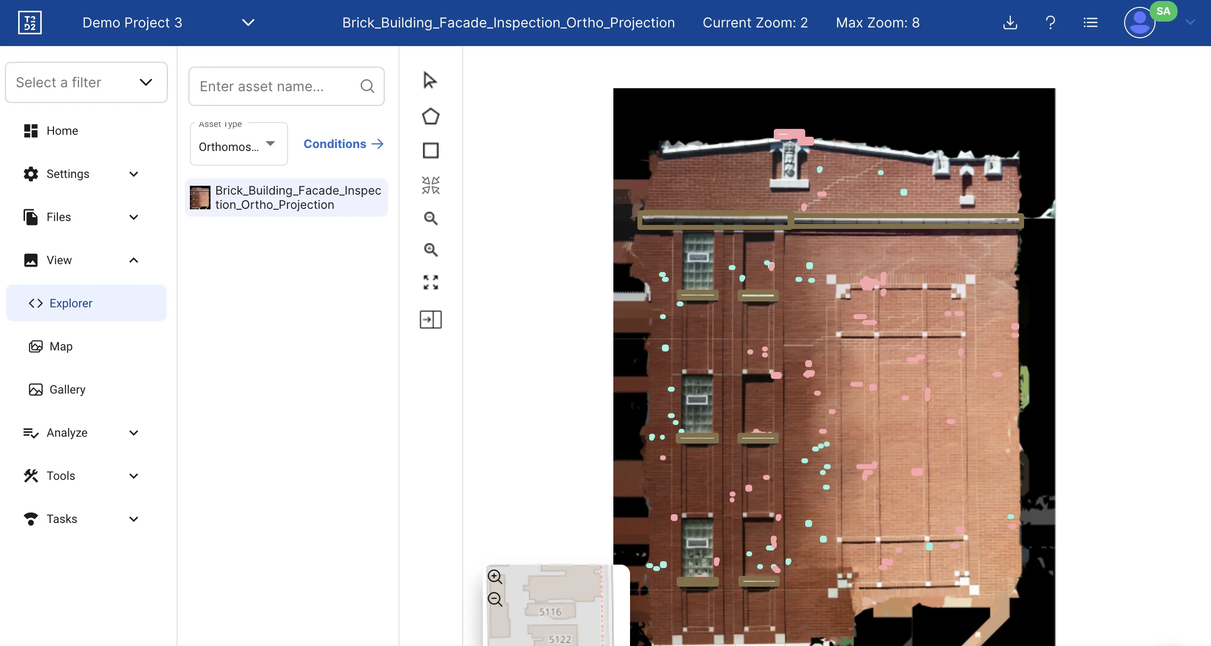
Printable Facade Orthomosaics
True-scale facade elevation images suitable for marking up conditions, planning repairs, and communicating scope to contractors.
Full-Envelope Visual + Thermal Data
Combined 50MP visual and FLIR thermal imagery gives engineers complete condition data for every facade surface, roof plane, and structural element.
AI-Assisted Condition Analysis
Machine learning pre-classifies defects before engineering review, accelerating the assessment process while maintaining PE-certified quality standards.
Services for AEC
Primary Services
These drone inspection services are most commonly requested by architecture & engineering professionals. Each includes PE-certified reporting and AI defect analysis.
3D Mapping
Photogrammetry-based 3D building models with 1-inch accuracy. Point cloud generation, BIM integration, and As-Built Documentation for arc...
Learn more →Facade Inspection
Comprehensive exterior building envelope scanning using drones and AI. 90-100% facade coverage with 20-50MP imagery, 3D models with 1-inc...
Learn more →Thermal Envelope Inspection
Infrared drone scanning to detect water intrusion, structural separation, insulation failure, and hidden defects invisible to the naked e...
Learn more →Additional Services
Roof Inspection
Residential and commercial drone roof inspections for storm damage assessment, leak detection, insurance claims support, and preventive m...
Learn more →AI-Powered Defect Detection
Automated AI analysis of drone inspection imagery. Detects up to 20 defect types including cracks, hairline cracks, corrosion, and spalli...
Learn more →Due Diligence Inspection
Comprehensive visual and thermal inspection to determine the true condition of an investment property. Condition assessment reports for p...
Learn more →AEC Applications
Common Use Cases
How architecture & engineering professionals use our drone inspection services to solve real problems.
As-Built Documentation
Accurate 3D models of existing buildings for renovation planning and BIM integration.
SB-4D Milestone Inspections
Comprehensive facade and structural condition data for milestone compliance reports.
Renovation Feasibility Studies
Detailed condition assessment to inform renovation scope, budget, and phasing.
Historic Preservation Documentation
High-resolution recording of architectural details for preservation and restoration projects.
FAQ
AEC Questions
Have a question not answered here? Contact us or call +1 (347) 998-1464.
What 3D data formats do you deliver?
We deliver point clouds (.las/.laz/.e57), textured mesh models (.obj/.ply), orthomosaics (.tiff/.jpg), and elevation profiles. These formats import directly into Revit, AutoCAD, Rhino, SketchUp, CloudCompare, and other standard AEC software. Custom formats are available on request.
What accuracy can I expect from drone photogrammetry?
Our standard deliverable achieves 1-inch (25mm) spatial accuracy, which is sufficient for most renovation planning, BIM integration, and condition assessment applications. For projects requiring higher precision, we can incorporate ground control points to achieve sub-centimeter accuracy.
Can your inspection data be used for SB-4D milestone reports?
Yes. Our PE-certified reports are specifically designed to support Florida SB-4D milestone inspection requirements. We provide the comprehensive visual and thermal data that structural engineers need to assess building condition and prepare their milestone reports.
How does AI analysis complement engineering judgment?
Our AI pre-classifies defects across thousands of images, identifying cracks, spalling, corrosion, moisture patterns, and other conditions with GPS coordinates and severity scoring. This gives the reviewing engineer a complete, organized defect inventory as a starting point — dramatically accelerating the assessment process without replacing professional judgment.
Do you work directly with engineering firms on SB-4D inspections?
Yes. We partner with engineering firms of record as the drone inspection subcontractor. The firm maintains responsibility for the SB-4D report, while we provide the comprehensive visual and thermal data, AI defect analysis, and 3D models that feed into their engineering assessment. We can also provide in-house PE-certified analysis when requested.
Free Assessment
Get Your AEC Inspection Quote
Tell us about your building and inspection requirements. We provide a custom quote — 1-hour average response time. Free assessment, no obligation.
PE-certified inspection report
AI defect classification with GPS coordinates
Industry-specific deliverables
Fast report delivery
Ready to Serve Your Architecture & Engineering Needs?
Free assessment. Custom quote — 1-hour average response time. PE-certified reports.
Before You Go
Get Your Free Inspection Quote
Takes 30 seconds. 1-hour average response time, 24/7.