Construction
Drone Inspection for Construction
Drone-based construction monitoring provides objective, timestamped documentation of every phase. From earthwork through closeout, our aerial inspections help general contractors, developers, and owners stay on schedule and catch issues before they become problems.
The Challenge
Construction Monitoring Challenges
Inconsistent Progress Tracking
Manual progress documentation is sporadic, subjective, and incomplete. Photos from ground level miss rooftop work, upper-floor installations, and site-wide context.
Compliance Verification Gaps
Verifying that work matches specifications requires comprehensive visual evidence. Spot-checks cover only a fraction of the work completed between site visits.
Stakeholder Communication
Owners, lenders, and remote stakeholders need regular visual updates. Compiling these updates manually is time-consuming and often delayed.
Dispute Documentation
Construction disputes require objective, timestamped evidence of site conditions. Without systematic aerial documentation, it becomes difficult to establish facts.
Our Solution
How AERIALLY.AI Solves These Challenges
Scheduled Aerial Documentation
Regular drone flights (weekly, bi-weekly, or monthly) capture comprehensive site conditions from above. Every image is GPS-referenced and timestamped.
DroneDeploy Integration
Interactive project maps, 3D models, and timelapse overlays give stakeholders intuitive visual access to project progress.
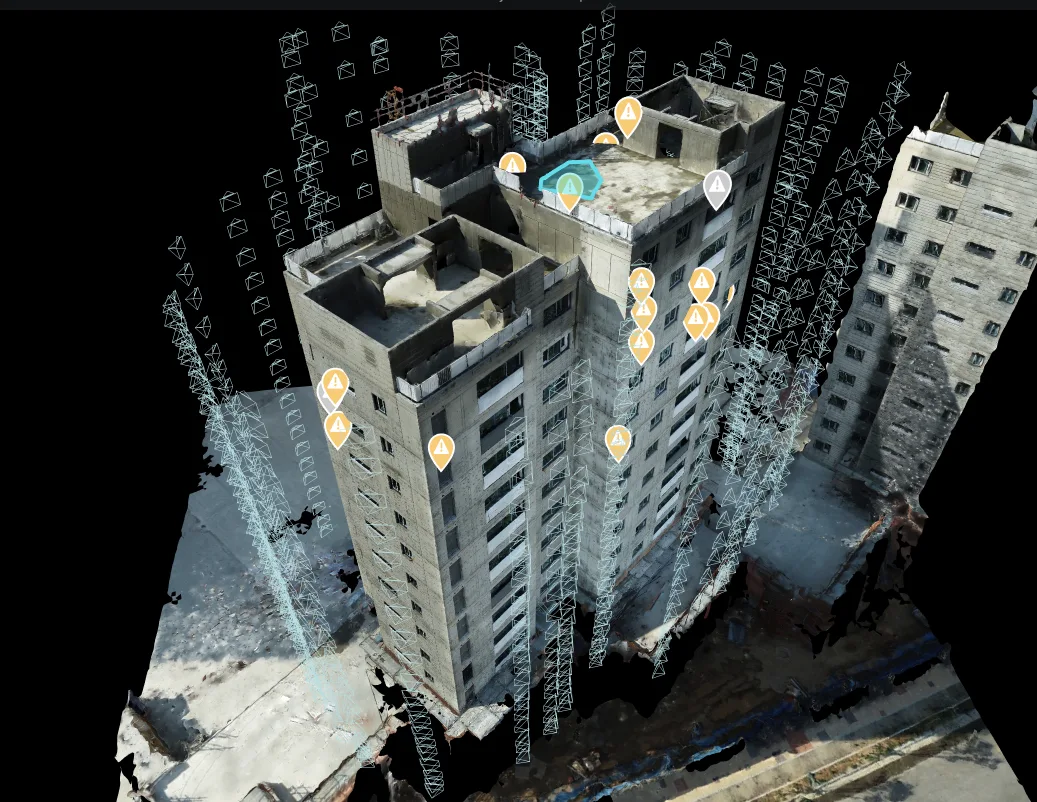
As-Built vs. Design Comparison
Overlay drone-captured conditions against design drawings to identify deviations early — before they require costly rework.
Objective Progress Records
Every flight creates a comprehensive, timestamped record of site conditions that serves as objective evidence for progress certification and dispute resolution.
Services for Construction
Primary Services
These drone inspection services are most commonly requested by construction professionals. Each includes PE-certified reporting and AI defect analysis.
Construction Monitoring
Drone-based construction progress documentation, timelapse recording, compliance verification, and stakeholder reporting for active job s...
Learn more →3D Mapping
Photogrammetry-based 3D building models with 1-inch accuracy. Point cloud generation, BIM integration, and As-Built Documentation for arc...
Learn more →Facade Inspection
Comprehensive exterior building envelope scanning using drones and AI. 90-100% facade coverage with 20-50MP imagery, 3D models with 1-inc...
Learn more →Additional Services
Roof Inspection
Residential and commercial drone roof inspections for storm damage assessment, leak detection, insurance claims support, and preventive m...
Learn more →Thermal Envelope Inspection
Infrared drone scanning to detect water intrusion, structural separation, insulation failure, and hidden defects invisible to the naked e...
Learn more →AI-Powered Defect Detection
Automated AI analysis of drone inspection imagery. Detects up to 20 defect types including cracks, hairline cracks, corrosion, and spalli...
Learn more →Construction Applications
Common Use Cases
How construction professionals use our drone inspection services to solve real problems.
Weekly Progress Documentation
Systematic aerial capture of construction site conditions at regular intervals.
Milestone Verification
Visual confirmation that work-in-place matches draw request specifications.
Quality Control Inspection
Identify installation defects, safety hazards, and specification deviations from above.
Project Closeout Documentation
Comprehensive as-built aerial record for owner turnover and warranty reference.
FAQ
Construction Questions
Have a question not answered here? Contact us or call +1 (347) 998-1464.
How often should construction sites be documented with drones?
Most active construction projects benefit from weekly or bi-weekly drone flights. The optimal frequency depends on project pace, complexity, and stakeholder requirements. We can adjust scheduling to align with draw request cycles, milestone dates, or specific phases.
Can drone monitoring integrate with our existing project management tools?
Yes. Our DroneDeploy integration provides interactive project maps, 3D site models, and timelapse views that can be shared with any web browser. We can also export data in formats compatible with Procore, PlanGrid, and other project management platforms.
Is drone monitoring safe around active construction?
Our FAA Part 107 certified pilots follow strict safety protocols for active construction environments. We coordinate with site superintendents on flight schedules, maintain safe distances from workers and equipment, and carry full commercial aviation insurance. Drone operations do not interrupt active work.
What deliverables do we receive after each flight?
Each monitoring flight produces: high-resolution aerial imagery (GPS-referenced, timestamped), interactive 2D orthomosaic map, optional 3D site model, progress comparison overlays, and a summary report highlighting notable changes since the previous flight.
Can drone data be used in construction disputes?
Yes. Our timestamped, GPS-referenced aerial imagery creates an objective, indisputable record of site conditions at each flight date. This documentation has been used effectively in schedule disputes, quality disagreements, and damage claims.
Free Assessment
Get Your Construction Inspection Quote
Tell us about your building and inspection requirements. We provide a custom quote — 1-hour average response time. Free assessment, no obligation.
PE-certified inspection report
AI defect classification with GPS coordinates
Industry-specific deliverables
Fast report delivery
Ready to Serve Your Construction Needs?
Free assessment. Custom quote — 1-hour average response time. PE-certified reports.
Before You Go
Get Your Free Inspection Quote
Takes 30 seconds. 1-hour average response time, 24/7.