3D Mapping
Your Building, Digitized to the Inch.
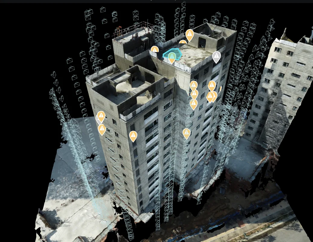
Photogrammetry-based 3D building models with 1-inch accuracy. Point clouds, BIM integration, and As-Built Documentation for architecture and engineering teams.
Starting at
$5,000
Based on building size and deliverable requirements.
PE-certified inspection report
AI defect classification with GPS coordinates
High-resolution drone imagery
Fast report delivery
Zero scaffolding required
Free assessment. No obligation.
The Problem
Manual Measurement Is Slow and Inaccurate
Traditional As-Built Documentation requires crews with tape measures and total stations, taking days or weeks to measure a single building. Results are often incomplete, and return visits are common when measurements are missed.
Our Solution
Drone Photogrammetry Captures Everything in One Visit
Our drones capture hundreds of overlapping images that are processed into precision 3D models, point clouds, and orthomosaics. Every surface is documented with 1-inch accuracy — no return visits needed. Output integrates directly with CAD and BIM workflows.
What You Receive
Deliverables
Every inspection includes a comprehensive suite of documentation designed for immediate action.
3D Point Cloud
Dense point cloud in LAS/LAZ format for CAD and BIM integration.
Textured 3D Model
Photorealistic mesh for visualization, measurement, and client presentations.
Printable Orthomosaic
Scaled facade and roof maps for scope-of-work and contractor coordination.
Elevation Profiles
Cross-section views for structural analysis and renovation planning.
BIM-Ready Export
IFC or Revit-compatible files for direct integration with design workflows.
Applications
When You Need This Service
As-Built Documentation
Accurate existing-condition documentation for renovation and retrofit projects.
Renovation Planning
Precise measurements enable architects to design without multiple site visits.
Heritage Preservation
Digital archival of historic structures for documentation and restoration planning.
Remote Measurement
Take measurements from the 3D model instead of returning to the building site.
FAQ
3D Mapping Questions
Have a question not answered here? Contact us or call +1 (347) 998-1464.
What accuracy can I expect?
Our photogrammetry achieves 1-inch accuracy for most building types. For higher precision requirements, we can incorporate ground control points.
What file formats do you deliver?
Standard deliverables include LAS/LAZ point clouds, OBJ/FBX meshes, GeoTIFF orthomosaics, and PDF elevation profiles. BIM exports in IFC or Revit format are available on request.
Can you scan the interior too?
Our primary focus is exterior aerial mapping. Interior scanning can be arranged as an additional service using ground-based LiDAR.
How does this compare to LiDAR scanning?
Drone photogrammetry provides excellent accuracy at lower cost for building exteriors. LiDAR may be preferred for very large sites or when sub-centimeter precision is required.
How long does processing take?
Point clouds and models are typically delivered within 3-5 business days. Rush delivery within 24-48 hours is available for an additional fee.
Free Assessment
Get Your 3D Mapping Quote
Tell us about your building and we provide a custom quote — 1-hour average response time. Free assessment, no obligation.
3D Mapping starts at $5,000. Based on building size and deliverable requirements.
Related Services
You May Also Need
Our services work together to provide comprehensive building analysis. Combine inspections for deeper insight.
Construction Monitoring
Drone-based construction progress documentation, timelapse recording, compliance verification, and stakeholder reporting for active job s...
Learn more →Facade Inspection
Comprehensive exterior building envelope scanning using drones and AI. 90-100% facade coverage with 20-50MP imagery, 3D models with 1-inc...
Learn more →AI-Powered Defect Detection
Automated AI analysis of drone inspection imagery. Detects up to 20 defect types including cracks, hairline cracks, corrosion, and spalli...
Learn more →Ready for 3D Mapping?
Free assessment. Custom quote — 1-hour average response time. PE-certified reports.
Before You Go
Get Your Free Inspection Quote
Takes 30 seconds. 1-hour average response time, 24/7.