Construction Monitoring
Track Every Pour. Document Every Phase.
Drone-based construction progress documentation with automated timelapse, compliance verification, and stakeholder reporting. Keep your project on schedule with visual proof.
Starting at
$1,500
Per flight. Volume discounts for recurring schedules.
PE-certified inspection report
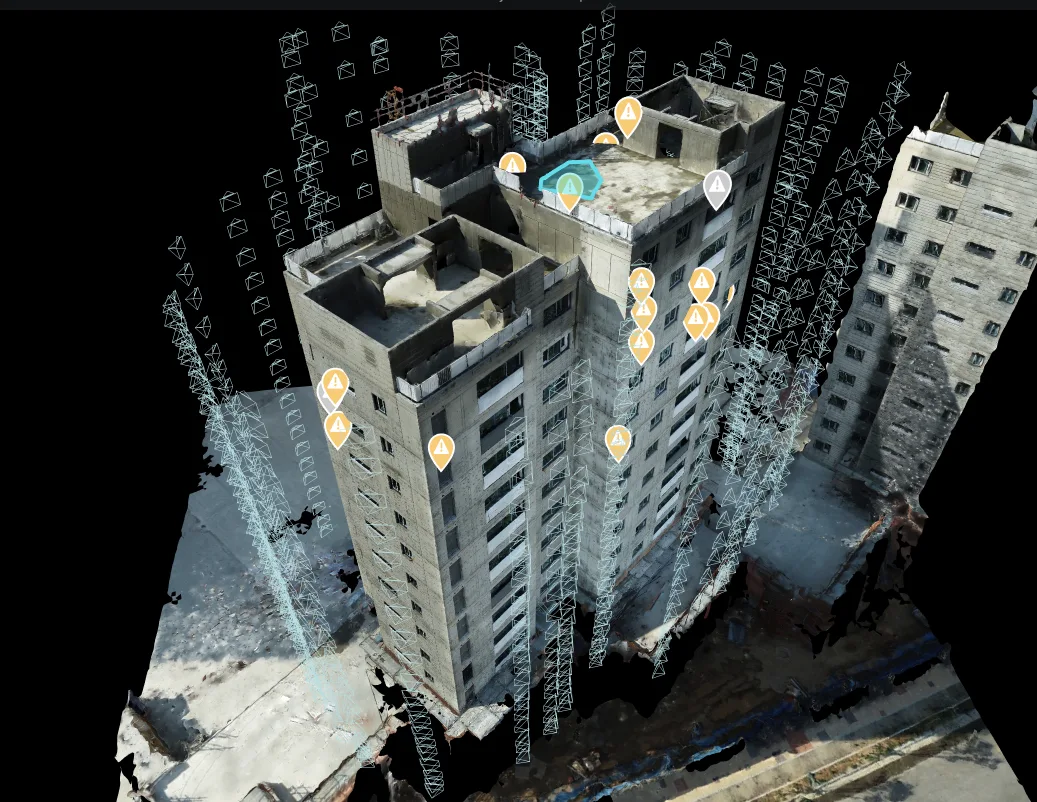
AI defect classification with GPS coordinates
High-resolution drone imagery
Fast report delivery
Zero scaffolding required
Free assessment. No obligation.
The Problem
Construction Documentation Is Manual and Incomplete
Site photos taken from the ground miss the big picture. Progress reports rely on verbal updates. Disputes arise over what was done when. Without comprehensive aerial documentation, project managers lose visibility into their own sites.
Our Solution
Scheduled Drone Flights Create a Visual Record
We capture aerial imagery on a regular schedule — weekly, bi-weekly, or monthly — creating a time-stamped visual record of construction progress. Orthomosaics provide measurable overhead views, while oblique imagery documents details from every angle.
What You Receive
Deliverables
Every inspection includes a comprehensive suite of documentation designed for immediate action.
Progress Orthomosaics
Scaled overhead maps for each capture date, measurable and comparable.
Visual Timelapse
Animated progress sequence showing construction advancement over time.
Comparison Reports
Side-by-side views highlighting changes between captures.
3D Site Model
Volumetric measurements for earthwork, concrete, and material tracking.
Stakeholder Dashboard
Shareable online viewer for remote project monitoring.
Applications
When You Need This Service
Progress Verification
Visual proof of milestones for payment draws and schedule compliance.
Quality Control
Aerial perspective reveals issues not visible from ground level.
Safety Monitoring
Identify safety hazards, site organization issues, and compliance gaps.
Dispute Resolution
Time-stamped visual evidence for resolving schedule or workmanship disputes.
FAQ
Construction Questions
Have a question not answered here? Contact us or call +1 (347) 998-1464.
How often do you fly the site?
We offer weekly, bi-weekly, and monthly capture schedules. Frequency can be adjusted as the project progresses through different phases.
Can you integrate with our project management software?
We deliver in standard formats compatible with DroneDeploy, Procore, PlanGrid, and other construction management platforms.
What about active construction zones?
We coordinate with your site superintendent to schedule flights during safe windows. All pilots are FAA Part 107 certified with construction site safety training.
Can you measure earthwork volumes?
Yes. 3D models generated from drone imagery enable accurate volumetric calculations for cut/fill, stockpile measurement, and material tracking.
Who has access to the reports?
We provide a secure online dashboard that you can share with any number of stakeholders — owners, architects, engineers, lenders, and contractors.
Free Assessment
Get Your Construction Quote
Tell us about your building and we provide a custom quote — 1-hour average response time. Free assessment, no obligation.
Construction Monitoring starts at $1,500. Per flight. Volume discounts for recurring schedules.
Related Services
You May Also Need
Our services work together to provide comprehensive building analysis. Combine inspections for deeper insight.
3D Mapping
Photogrammetry-based 3D building models with 1-inch accuracy. Point cloud generation, BIM integration, and As-Built Documentation for arc...
Learn more →Facade Inspection
Comprehensive exterior building envelope scanning using drones and AI. 90-100% facade coverage with 20-50MP imagery, 3D models with 1-inc...
Learn more →Thermal Envelope Inspection
Infrared drone scanning to detect water intrusion, structural separation, insulation failure, and hidden defects invisible to the naked e...
Learn more →From the Blog
Related Articles
Ready for Construction Monitoring?
Free assessment. Custom quote — 1-hour average response time. PE-certified reports.
Before You Go
Get Your Free Inspection Quote
Takes 30 seconds. 1-hour average response time, 24/7.